Science > Physics > Communication > Satellite Communication
Radio Communication uses ground wave, skywave, and space wave propagation. Ground wave and space wave communication are restricted to small distances, whereas skywave propagation uses frequencies ranging from 3 MHz to 30 MHz. Very high frequency (> 30 MHz) and microwave communication over long distances use a Satellite. Satellite communication is useful in sending a large amount of information in a small-time over a large distance.
The Principle of satellite communication:
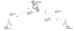
A communication satellite carrying microwave transmitting and receiving equipment called radio transponders is placed in the geostationary orbit of the earth. A beam of modulated microwaves carrying the Signal is directed towards the satellite. This is known as uplinking. The satellite receives the signal; amplifies and redirects it after re-modulation to a receiving station on earth by using a different carrier wave. This is known as downlink. To avoid confusion the uplink and downlink frequencies are kept different. Frequency modulation is used for both up channel and down channel transmission. Frequency modulation is preferred because it offers good immunity from interference and it requires less power in the transmitter of the satellite. Satellites are generally powered by solar batteries.

Geostationary Satellite:
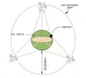
A communication satellite or geostationary satellite is an artificial satellite which revolves in a circular orbit around the earth in the equatorial plane such that, a) its direction of motion is the same as the direction of rotation of the ‘earth about its axis. and b) its period is the same as the period of rotation of the earth, i.e. 24 hours.
When observed from the earth’s surface, this satellite appears stationary. Therefore, it is called a geostationary satellite. As its motion is synchronous with the rotational motion of the earth, it is called a geosynchronous satellite. The height of the communication satellite above the surface of the earth is about 36,000 km. The angle made by the orbit of geostationary orbit with the equatorial plane is 0°.
Notes:
- The orbit of the geosynchronous satellite is called geosynchronous orbit.
- It lies in an equatorial plane. i.e. the angle between geosynchronous orbit and the equatorial plane is 0°.
- The radius of the geosynchronous orbit is about 42400 km.
- The satellite parking strip is an area over the equator is becoming congested with several hundreds of communication, weather, military, and transmission satellites.
Uses of Communication Satellites:
- The communication satellites are used for sending microwave and TV signals from one place to another.
- The communication satellite is used for telephony.
- The communication satellites are used for weather forecasting.
- The communication satellites are used for detecting water resource -locations and areas rich in ores.
- The communication satellites are used for spying In enemy countries i.e. It can be used for military purposes
Polar or Sun-synchronous Satellite:
A polar satellite is a low altitude satellite orbit around the earth in north-south orbit passing over the north pole and south pole. The orbit of the polar satellite is called polar orbit. The polar orbit makes an angle of inclination of 90° with the equatorial plane. Polar satellites cross the equatorial plane at the same time daily The height of the polar satellite above the earth is about 500-1000 km.
To understand the Earth’s atmosphere and changes in it, the whole planet must be scanned periodically and most effectively. To this polar satellites are used. The information gathered from polar satellites is extremely useful for remote sensing, meteorology as well as for environmental studies of the earth. These satellites are not used for communication.
Advantages of Polar Satellite:
Geostationary satellites are fixed at one position w.r.t. the earth at height 36000 km above the Earth. Its long-range helps meteorologists to understand and analyze the weather. But to understand Earth’s atmosphere and changes in the atmosphere, the whole planet must be scanned periodically and most effectively. To this polar satellites are used.
Since its time period is about 100 minutes it crosses any altitude many times a day and its height h above the earth is about 500-800 km, a camera fixed on it can view only small strips of the earth in one orbit. Adjacent strips are viewed in the next orbit so that in effect the whole earth can be viewed strip by strip during the entire day. From the path shown in the figure, we can see that it covers almost all geographical areas.
Satellite in Highly Elliptical Orbit:
These satellites are used for communication in high latitude regions. The preferred inclination of the orbit with the equatorial plane is 63°.
Global Communication:
A single communication satellite covers about one-third of the earth’s surface. Therefore in order to achieve communication link over the entire globe, we need a minimum of three communication satellites which are 120° apart. Microwave signals are transmitted from one satellite to another with each satellite covering one-third of the globe. Thus, interlinking between these satellites covers the entire earth’s surface.

Satellite Communication is Costly:
The satellite communication is costly due to the following reasons
- The life of the satellite depends on its fuel capacity. Hence the life of the satellite is limited. It is required to be replaced after some time.
- The cost of making satellite and launching is more.
- A precise control system is required for monitoring satellite.
Note:
Satellite communication is costly but it costs very less compared to laying of the line network.
Previous Topic: Antenna and its Coverage Area Calculations
Next Topic: Communication Channels: Wires, Cables, and Optical Fibres