India is a country located in the continent of Asia.
Extent:
The mainland of India extends from Kashmir in the north to Kanyakumari in the south and Arunachal Pradesh in the east to Gujarat in the west. India’s territorial limit further extends towards the sea up to 12 nautical miles (about 21.9 km) from the coast.
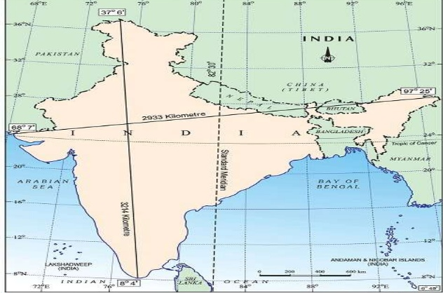
The actual distance measured from north to south extremity is 3,214 km, and that from east to west is only 2,933 km.
The country is situated north of the equator between 8°04′ to 37°06′ north latitude and 68°07′ to 97°25′ east longitude. From the values of latitude, it is understood that the southern part of the country lies within the tropics and the northern part lies in the sub-tropical zone or the warm temperate zone.
Advantages of latitudinal spread: The location is responsible for large variations in landforms, climate, soil types and natural vegetation in the country.
Time Spread:
India’s longitudes are68°07′ to 97°25′ east. Thus the longitudinal spread of India is about 30° and territorial spread is 2,933 km. Due to which the sun rises in the northeastern states about two hours earlier as compared to Jaisalmer in Rajasthan (the west most part of India)In India we have Indian Standard Tim (IST) all over India. Hence the watches in Dibrugarh, Imphal in the east and Jaisalmer, Bhopal or Chennai in the other parts of India show the same time.
Indian Standard Time is calculated as 82°30′ east longitude (standard meridian) and watches all over India are set accordingly. Indian Standard Time is ahead of Greenwich Mean Time by 5 hours and 30 minutes.
Due to its wide east-west spread, India should have more than one standard meridian. Some countries have more than one meridian. In the US there are 7 meridians.
Area:
India with its area of 3.28 million sq. km accounts for 2.4 percent of the world’s land surface area and stands as the seventh largest country in the world.
India is the second largest country in Asia; it is 4 times larger than Pakistan, 8 times larger than Japan, 12 times larger than the U.K. but 3 times smaller than the USA.
Geographical Characteristics:
The large size of India has endowed her with great physical diversity. There are lofty mountains in the north; large rivers such as Ganga, Brahmaputra, Mahanadi, Krishna, Godavari, and Kaveri; green forested hills in northeast and south India; and the vast sandy expanse of Marusthali.
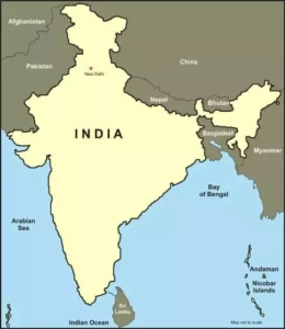
India is bounded by the Himalayas in the north, Hindukush and Sulaiman ranges in the northwest, Purvachal hills in the north-east and by the large expanse of the Indian ocean in the south, it forms a great geographic entity known as the Indian subcontinent. It includes the countries: Pakistan, Nepal, Bhutan, Bangladesh, and India.
The Himalayas, together with other ranges, have acted as a formidable physical barrier in the past. Except for a few mountain passes such as the Khyber, the Bolan, the Shipkila, the Nathula, the Bomdila, etc. it was difficult to cross it. It has contributed towards the evolving of a unique regional identity of the Indian subcontinent.
The Indian Ocean. , the Arabian Sea and the Bay of Bengal have provided the country with a coastline of 6,100 km in the mainland and 7,517 km in the entire geographical coast of the mainland plus the island groups Andaman and Nicobar located in the Bay of Bengal and the Lakshadweep in the Arabian Sea.
Advantages of long cost line:
Thus India, as a country, is a physically diverse land providing the occurrence of varied resources.
India and its Neighbours:
India is located in the south-central part of the continent of Asia, bordering the Indian ocean and its two arms extending in the form of the Bay of Bengal and the Arabian Sea. This maritime location of Peninsular India has provided links to its neighbouring regions through the sea and air routes.
Sri Lanka and the Maldives are the two island countries located in the Indian Ocean, which are neighbours of India. Sri Lanka is separated from India by the Gulf of Mannar and Palk Strait.
India is bordered on the North by Pakistan, China, Nepal, and Bhutan; on the East by Myanmar, Bangladesh, and the Bay of Bengal; on the South by the Indian Ocean; on the West by the Arabian Sea; and on the North-West by Pakistan. The total boundary length is 21,103 km, of which 7,517 km is coastline.